Common names from other countries
Environment: milieu / climate zone / depth range / distribution range
Ecologia
Demersal; Água doce; estuarina; intervalo de profundidade 0 - 13 m (Ref. 116169), usually 2 - 5 m (Ref. 81178). Tropical; 38°N - 21°S, 89°W - 35°W
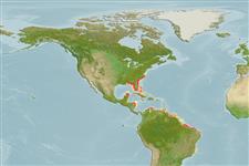
Western Atlantic: Trichechus manatus manatus: from the coasts and rivers of Mexico to as far south to Rio Doce, Brazil including the Orinoco and Amazon; Trichechus manatus latirostris: from the Florida Peninsula to Rhode Island. Tropical to temperate.
Length at first maturity / Tamanho / Peso / Idade
Maturity: Lm ? range ? - ? cm Max length : 390 cm TL macho/indeterminado; (Ref. 1394); Peso máx. publicado: 1.6 t (Ref. 1394)
Found in coastal marine, brackish and freshwater areas. Feeds on aquatic plants, (i.e. water hyacinths and marine seagrasses, algae, parts of mangrove trees, floating and shoreline vegetation); invertebrates (i.e. tunicates); and fish they remove from fishing nets (Ref. 1394). Found in coastal marine, brackish and freshwater areas (Ref. 1394), where primary habitat consists of rivers, coastal lagoons and bays and mangrove islands (Ref. 86755). Feeds on aquatic plants, (i.e. water hyacinths and marine seagrasses, algae, parts of mangrove trees, floating and shoreline vegetation); invertebrates (i.e. tunicates); and fish they remove from fishing nets (Ref. 1394).
Jefferson, T.A., S. Leatherwood and M.A. Webber. 1993. (Ref. 1394)
Status na Lista Vermelha da IUCN (Ref. 130435)
Status no CITES (Ref. 108899)
Uso pelos humanos
Pescarias: espécies comerciais
FAO - pescarias: perfil da espécie | FishSource | Sea Around Us
Ferramentas
Mais informação
Idade/Tamanho
Crescimento
Comprimento-peso
Comprimento-comprimento
Morfologia
Larvas
Abundância
Fontes da internet
Estimates based on models
Preferred temperature
(Ref.
115969): 22.9 - 28, mean 26.5 (based on 562 cells).
Vulnerabilidade
Very high vulnerability (90 of 100).
Categoria de preço
Unknown.


")