Advertisement

You can sponsor this page

Trichechus manatus   Linnaeus, 1758

West Indian manatee

Native range | All suitable habitat | Point map | Year 2050
This map was computer-generated and has not yet been reviewed.
Trichechus manatus  AquaMaps  Data sources: GBIF OBIS
Upload your photos 
| All pictures | Google image |
Image of Trichechus manatus (West Indian manatee)
Trichechus manatus


Bahamas country information

Common names: [No common name]
Occurrence: native
Salinity: marine
Abundance: | Ref:
Importance: | Ref:
Aquaculture: never/rarely | Ref:
Regulations: no regulations | Ref:
Uses: no uses
Comments: Previous occurrence from map (Ref. 1394, p. 207) is confirmed by Ref. 1522. Reported as Trichechus manatus latirostris (Ref. 1522). C: Ref. 1522, M: Ref. 1394.
National Checklist:
Country Information: https://www.cia.gov/library/publications/resources/the-world-factbook/geos/bf.html
National Fisheries Authority: http://www.caricom-fisheries.com/bahamas-fisheries
Occurrences: Occurrences Point map
Main Ref: Rice, D.W., 1998
National Database:

Common names from other countries

Classification / Names / Names Κοινά ονόματα | Συνώνυμα | Catalog of Fishes (gen., sp.) | ITIS | CoL | WoRMS

> Sirenia (Dugongs and manatees) > Trichechidae ()

Environment: milieu / climate zone / depth range / distribution range Οικολογία

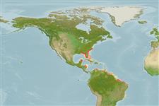
βενθικό(ς); Γλυκού νερού; Υφάλμυρο; εύρος βάθους 0 - 13 m (Ref. 116169), usually 2 - 5 m (Ref. 81178).   Tropical; 38°N - 21°S, 89°W - 35°W

Κατανομή Χώρες | Περιοχές FAO | Οικοσυστήματα | Παρουσίες | Εισαγωγές

Western Atlantic: Trichechus manatus manatus: from the coasts and rivers of Mexico to as far south to Rio Doce, Brazil including the Orinoco and Amazon; Trichechus manatus latirostris: from the Florida Peninsula to Rhode Island. Tropical to temperate.

Length at first maturity / Μέγεθος / Βάρος / Age

Maturity: Lm ?  range ? - ? cm Max length : 390 cm TL αρσενικό/απροσδιόριστο; (Ref. 1394); μεγ. δημοσιευμένο βάρος: 1.6 t (Ref. 1394)

Βιολογία     Γλωσσάρι (π.χ. epibenthic)

Found in coastal marine, brackish and freshwater areas. Feeds on aquatic plants, (i.e. water hyacinths and marine seagrasses, algae, parts of mangrove trees, floating and shoreline vegetation); invertebrates (i.e. tunicates); and fish they remove from fishing nets (Ref. 1394). Found in coastal marine, brackish and freshwater areas (Ref. 1394), where primary habitat consists of rivers, coastal lagoons and bays and mangrove islands (Ref. 86755). Feeds on aquatic plants, (i.e. water hyacinths and marine seagrasses, algae, parts of mangrove trees, floating and shoreline vegetation); invertebrates (i.e. tunicates); and fish they remove from fishing nets (Ref. 1394).

Main reference Αναφορές | Συντονιστής | Συνεργάτες

Jefferson, T.A., S. Leatherwood and M.A. Webber. 1993. (Ref. 1394)

IUCN Red List Status (Ref. 130435)

  Ευάλωτο, βλέπε Κόκκινη Λίστα (VU) (C1); Date assessed: 30 June 2008

CITES status (Ref. 108899)


CMS (Ref. 116361)

Human uses

αλιεία: Εμπορικό(ά)
FAO - αλιεία: species profile | FishSource | Η θάλασσα γύρω μας

Εργαλεία

Περισσότερες πληροφορίες

Κοινά ονόματα
Συνώνυμα
Θηρευτές
Αναπαραγωγή
Γεννητική Ωρίμανση
Γεννοβολία
Γονιμότητα
Αβγά
Egg development
Age/Size
Αύξηση
Length-weight
Length-length
Μορφολογία
Προνύμφες
Αφθονία
Αναφορές
Mass conversion

Διαδικτυακές πηγές

BHL | BOLD Systems | CISTI | DiscoverLife | FAO(αλιεία: species profile; publication : search) | GenBank (genome, nucleotide) | GloBI | Gomexsi | Google Books | Google Scholar | Google | PubMed | Δέντρο Ζωής | Wikipedia (Go, αναζήτηση) | Zoological Record

Estimates based on models

Preferred temperature (Ref. 115969): 22.9 - 28, mean 26.5 (based on 562 cells).
Vulnerability (Ref. 71543): Very high vulnerability (90 of 100).
Price category (Ref. 80766): Unknown.