Advertisement

You can sponsor this page

Portunus segnis   (Forskål, 1775)


Native range | All suitable habitat | Point map | Year 2050
This map was computer-generated and has not yet been reviewed.
Portunus segnis  AquaMaps  Data sources: GBIF OBIS
Adicionar o seu Fotografias 
| Todas as fotos | Imagem do Google |
Image of Portunus segnis
Portunus segnis


Oman country information

Common names: [No common name]
Occurrence: native
Salinity: marine
Abundance: | Ref:
Importance: | Ref:
Aquaculture: | Ref:
Regulations: | Ref:
Uses: no uses
Comments: Known from off Raysut, Khawr Rowri, Dhofar, Island of Masira, Al-Wusta; Sharkiyah, Muscat, Batinah, and Khasab (Refs. 106287, 129339). Observed on intertidal mudflats in Barr Al Hikman (Ref. 128960). C: Refs. 106287, 106352, 111207, 128960.
National Checklist:
Country Information: https://www.cia.gov/library/publications/resources/the-world-factbook/geos/mu.html
National Fisheries Authority:
Occurrences: Occurrences Point map
Main Ref: Bom, R.A., J.A. van Gils, K. Molenaar, A.Y. Kwarteng, R. Victor and E.O. Folmer, 2020
National Database:

Common names from other countries

Classification / Names / Names Nomes comuns | Sinónimos | Catalog of Fishes (gen., sp.) | ITIS | CoL | WoRMS

> Decapoda (Lobster, shrimp and crabs) > Portunidae (swimming crabs)

Environment: milieu / climate zone / depth range / distribution range Ecologia

; intervalo de profundidade 0 - 65 m (Ref. 106819).   Tropical

Distribuição Países | Áreas FAO | Ecossistemas | Ocorrências | Introduções

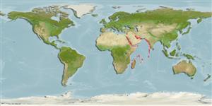
Western Indian Ocean: From Pakistan westwards to the Arabian Gulf extending to the east African coast to South Africa and to Madagascar and Mauritius. Introduced in the Mediterranean through the Suez Canal and established up to the northern Tyrrhenian Sea.

Length at first maturity / Tamanho / Peso / Idade

Maturity: Lm 7.4  range ? - ? cm Max length : 16.2 cm CW macho/indeterminado; (Ref. 115276); 16.2 cm CW (female)

Biologia     Glossário (ex. epibenthic)

Lives mainly in coastal waters in seagrass meadows and along mangroves (Ref. 115276), and intertidal mudflats (Ref. 128960). Found under rocks and in rock pools, on sandy or muddy substrate (Ref. 111207). Larger biomass is seen between depths of 2 to 15 m. Small juveniles are found in very shallow waters (less than 1 m); females occupy deep-water zones during spawning (Ref. 115276). Opportunistic predator, primarily a carnivore preying on a variety of benthic animals and less marine plants and seagrass (Ref. 108412). Prolific predators of bivalves. Some suggested that they're opportunistic omnivores or detritivores, feeding on carrion, especially on fishing-discards. Efficient night time forager, using a characteristic zigzag search pattern to locate prey (Ref. 115276).

Referência principal Referências | Coordenador | Colaboradores

Safaie, M., J. Pazooki, B. Kiabi and M.R. Shokri. 2013. (Ref. 107016)

Categoria na Lista Vermelha da IUCN (Ref. 130435)


Categoria CITES (Ref. 108899)

Not Evaluated

CMS (Ref. 116361)

Not Evaluated

Ameaça para o homem

  Harmless

Utilização humana


| FishSource |

Ferramentas

Mais informação

Países
Áreas FAO
Ecossistemas
Ocorrências
Introduções
Stocks
Ecologia
Dieta
Itens alimentares
Nomes comuns
Sinónimos
Predadores
Reprodução
Maturidade
Desova
Fecundidade
Ovos
Desenvolvimento dos ovos
Idade/Tamanho
Crescimento
Comprimento-peso
Comprimento-comprimento
Morfologia
Larvas
Abundância
Referências
Mass conversion

Fontes da internet

BHL | BOLD Systems | CISTI | DiscoverLife | FAO(Publication : search) | GenBank (genoma, nucleotídeo) | GloBI | Gomexsi | Google Books | Google Scholar | Google | PubMed | Árvore da vida | Wikipedia (ir para, procurar) | Registo zoológico

Estimates based on models

Resiliência (Ref. 69278) Elevada, tempo mínimo de duplicação da população menor que 15 meses (K=1.6-1.7).